
Developers from ERDC’s Enhanced Terrain Processing effort demonstrate their binary built-up areas tool to Sgt. 1st Class Jung Hong from the Army Geospatial Center’s Military Support Team (MST). Working closely with MST enables the ERDC team to thoroughly and more rapidly vet the tools it is developing and ensure they are meeting Solider needs and expectations. (Photo by ERDC)
ERDC is developing enhanced terrain-processing tools to improve Soldiers’ maneuver capabilities and far more.
by Chris Kieffer
It’s 2025, and U.S. forces are encamped on the outskirts of a dense rain forest.
A team of geospatial engineers studies maps that depict the surrounding terrain as they plan a troop movement that must keep the unit concealed. These maps will be used to guide where and how to move troops, such as the best path Soldiers can take and remain hidden underneath trees, or available routes where Humvees can be driven or where helicopters can safely land.
Suddenly, a commander bursts into the room and halts their progress. She tells them the situation is fluid. The area of interest has shifted significantly and she needs a new plan in two hours.
It’s a complicated task. The new area is unfamiliar, and there is no existing map that details where its tree canopy is thick enough to cover the troops, where its tree trunks are spaced far enough apart to support the maneuver or where it contains hidden wetlands that should be avoided. And producing this terrain analysis by hand using traditional methods could take a full day’s work, delaying the start of the operation.
Instead, the engineers upload the latest satellite imagery into a suite of Enhanced Terrain Processing tools developed by the U.S. Army Engineer Research and Development Center (ERDC). Within minutes, they have the land-cover map they need. Possessing a detailed understanding of the nearby terrain and forest cover, the engineers can quickly get back to work on producing a revised route for the maneuver to enable mission success.
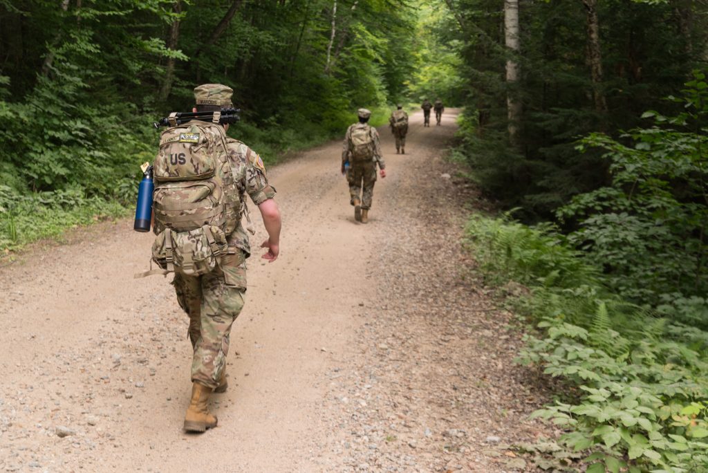
ROADS LESS MAPPED: Soldiers from the 362nd Mobile Public Affairs Detachment conduct a ruck march before a field training exercise in Livermore, New Hampshire, in August 2020. ERDC’s Enhanced Terrain Processing tools will enable Army geospatial engineers to better plan troop movements, such as those that must be concealed by tree cover. (Photo by Staff Sgt. Ray Boyington, 362nd Mobile Public Affairs Detachment)
GROUND TRUTH
When planning an operation, military leaders must quickly know that the information on their maps hasn’t changed. For example, a grove of trees may no longer be present, what was once agricultural land may now be overgrown, or a dry plain may have been overtaken by a flood. However, extracting this information from newer satellite imagery is a lengthy and complicated process.
ERDC’s Enhanced Terrain Processing effort is developing a series of tools to solve this problem. These tools allow Army geospatial engineers to rapidly process new remotely sensed imagery from a variety of sources and use it to analyze current terrain conditions. (The official name of the program is Tactical Geospatial Information Capabilities – Enhanced Terrain Processing. Enhanced Terrain Processing is one of four projects under that larger umbrella and also the name of this toolset.)
Within minutes, geospatial engineers can produce a land-cover-classification map that highlights the location of a variety of features, such as vegetation, evergreen or deciduous trees, wetlands, farms and built-up areas. Other tools rapidly identify the location of forests and water, tree density and crown diameter, terrain ruggedness and optimal mobility corridors, among many other features.
“Creating foundational geospatial data, such as land-cover maps, takes time—anywhere from a few hours to a few days depending on which technique you are using, what you’re trying to produce, and the size of your area of interest,” said Nikki Wayant, research geographer at ERDC’s Geospatial Research Laboratory and task lead for the Enhanced Terrain Processing effort.
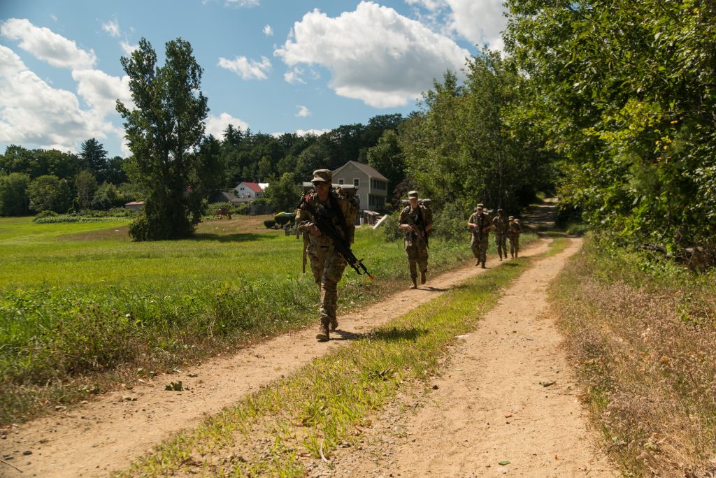
ON-THE-MOVE: Soldiers from the 362nd Mobile Public Affairs Detachment conduct squad movements during a field training exercise in Rochester, New Hampshire, in August 2020. New tools being developed by ERDC will enable Army geospatial engineers to develop better terrain analysis products using new remotely sensed data, enabling leaders to better plan troop movements through various types of terrain in unfamiliar areas. (Photo by Staff Sgt. Ray Boyington, 362nd Mobile Public Affairs Detachment)
YOU NEED IT WHEN?
ERDC is providing several tools that automate these processes—producing information that is more accurate and of better resolution, and doing it more quickly than with traditional methods. They can also combine information in new ways to provide analysis products that depict optimal cross-country terrain routes, available helicopter landing zones or areas of cover and concealment, just to name a few.
“In the past, people had a couple of days to put something out,” Wayant said. “The fact of the matter is, currently, the geospatial engineer does not have the days they would need to create a very well-thought-out geospatial product. Their commanders do not always understand the amount of time it takes, so they are like, ‘I need this in 30 minutes.’ And the geospatial engineers are just doing the best they can with the tools they have, and it’s not always the most accurate. And so, they have to give it with a lot of caveats. Or it does take them several days to walk through the process to create all of these products. Now the geospatial engineers can do them so much quicker, and they can trust them more.”
This matters because when a unit begins its maneuver, it doesn’t want to send a tank to an area that has been recently overgrown with trees or a Humvee to a spot where a rainstorm saturated the soil enough that it will not currently support the vehicle’s weight.
“Being able to have more up-to-date information means it is more likely for a mission to be completed,” Wayant said. “It allows us to plan a mission faster and more accurately, making sure it is able to be completed, but also making sure we can bring Soldiers home safely.”
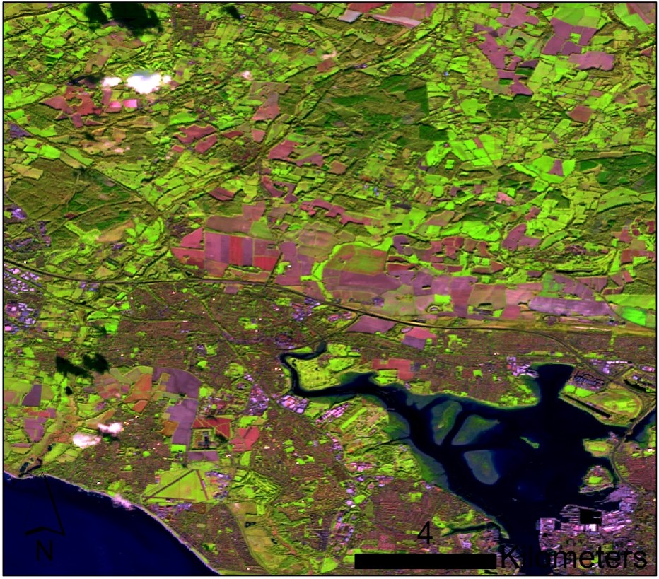
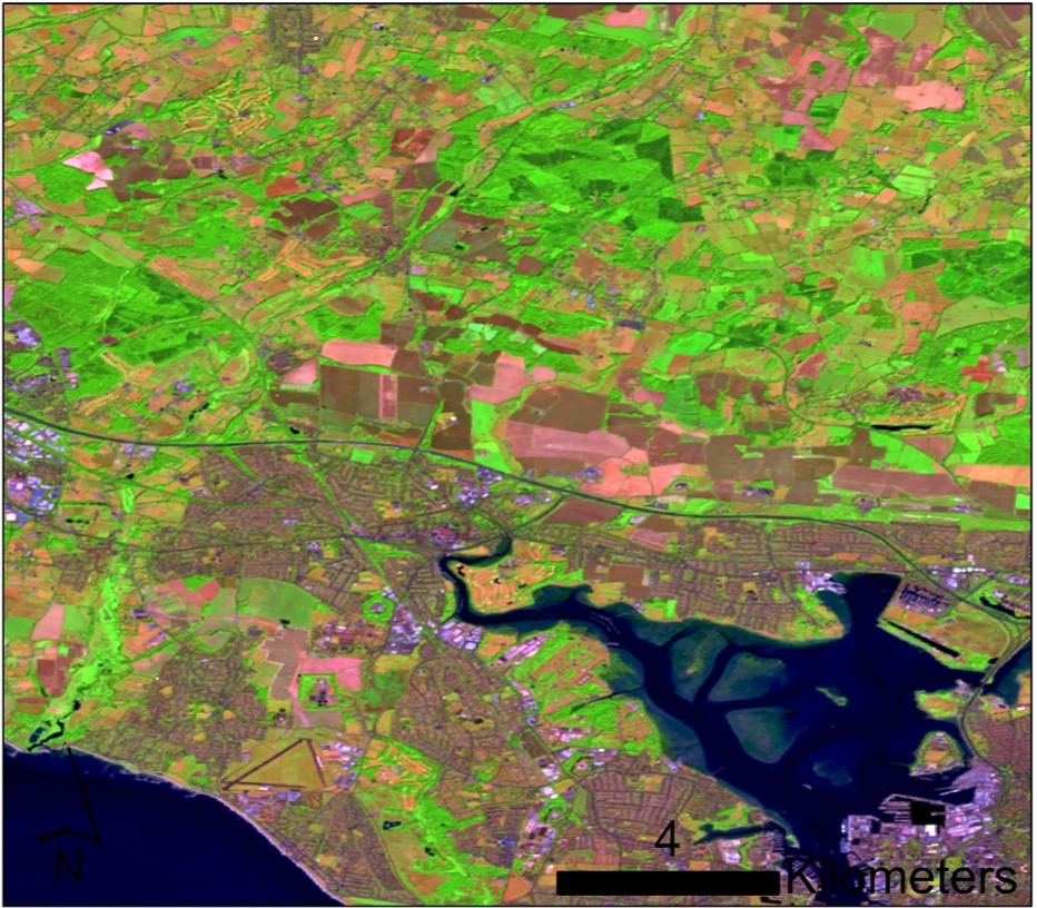
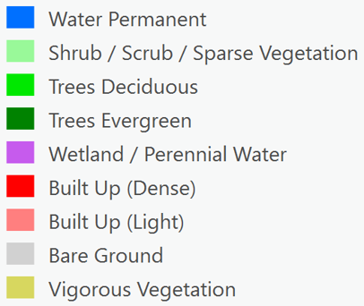
GROUND, COVERED: One of the applications in ERDC’s Enhanced Terrain Processing toolset can take two satellite images of an area—one from the summer and one from the winter—and rapidly process them to create a detailed land-cover map that highlights the location of various features, such as water, vegetation, deciduous and evergreen trees, wetlands, and built-up areas. (Images courtesy ERDC)
CONCLUSION
Many of these tools will be formally tested during the maneuver, support, sustainment and protection integration experiments capability demonstration in May at Fort Leonard Wood, Missouri. They should be available to Army geospatial engineers by fiscal year 2024 or 2025.
ERDC’s Enhanced Terrain Processing team works in close collaboration with the Army Geospatial Center’s Military Support Team, which is made up of geospatial engineers who have field experience. This allows the ERDC team to thoroughly vet the tools it is developing and ensure they are meeting Solider needs and expectations.
And the effort continues to evolve, using advances in machine learning to combine information in new ways and provide new capabilities, like automatically extracting buildings and roads from images or determining the density of trees within a forest.
“We’re trying to take advantage of all of the progress being made in other disciplines such as computer science and using that to solve some of the geospatial problems we are facing today,” Wayant said.
“One of the things I think that makes Enhanced Terrain Processing so successful is the diversity we have in terms of skillsets,” Wayant said. “We have geographers, we have computer scientists, we have physicists. We have foresters. So, we are able to combine all of the knowledge and science behind all of the disciplines together to create these products.”
For more information and to learn more about ERDC’s Enhanced Terrain Processing tools, listen to an interview with Nikki Wayant on the Power of ERDC Podcast at https://poweroferdcpodcast.org/enhanced-terrain-processing/, or search for “Power of ERDC” in all major podcast players. You can send information requests to ERDCinfo@usace.army.mil.
CHRIS KIEFFER is a communications specialist with the U.S. Army Engineer Research and Development Center. He spent more than a decade as a reporter and editor with the Northeast Mississippi Daily Journal and Oxford (Mississippi) Eagle newspapers. Kieffer holds an M.S. in journalism from Columbia University and a B.A. in journalism from the University of Mississippi.