Precision-guided munitions fly to the sound of different GPS signals.
by Paul Manz and Thomas Blenk
On Oct. 12–14, 2021, Joint Program Executive Office Armaments and Ammunition (JPEO AA)’s Assured Precision Weapons and Munitions team and its partners successfully executed the first-ever network-assisted M-code GPS precision-guided munition live-fire developmental test at Yuma Proving Ground in conjunction with Project Convergence 2021.
Until recently, most precision-guided munitions used an encrypted GPS reference signal called P(Y)-code to help them accurately fly to and engage an enemy target (P-code is precise code. P(Y)-code is encrypted code to protect against spoofing). Now, after many decades of using P(Y)-code GPS signals, precision-guided munitions are migrating to a new, enhanced military GPS signal called M-code. M-code GPS has many benefits, including improved GPS jamming resistance, improved ability to determine enemy spoofing of GPS signals and enhanced cryptography for improved security.

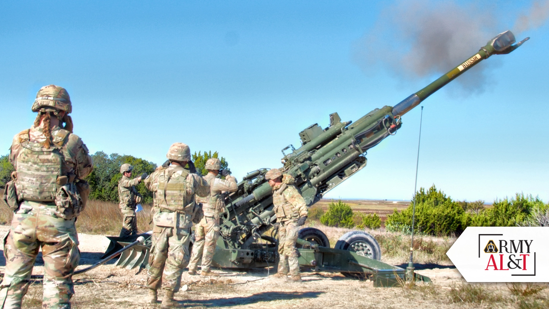
DATA ASSURANCE: JPEO AA’s new prototype Network-Assisted Assured Positioning, Navigation, and Timing—or NA2—capability provides automated worldwide distribution of an expanded set of assured position, navigation and timing hot start data needed by precision-guided munitions. (Photo by Staff Sgt. Desmond Cassell, DVIDS)
OFF TO A HOT START
The ability to use any form of GPS, including M-code GPS, is based on the user or platform being able to “see” GPS, “hear” GPS and know what is being heard is “truth” in a timely manner.
Seeing GPS means the user or platform—in this case, a precision-guided munition—must have direct view of “sufficient” overhead GPS satellites to determine its location in simplistic terms of X, Y and Z coordinates. Sufficient GPS satellites mean a weapon or precision-guided munition must always see at least four GPS satellites, noting that seeing more than four satellites that are wide-spread across the sky results in even better positioning accuracy. The information (such as satellite location, timing and “health” information) from GPS satellites seen at the weapon can be used to “hot start” the precision-guided munition. This pre-loaded hot start information allows the precision-guided munition to more rapidly see and hear GPS signals after launch and help in determining if those signals are truth or spoofed signals.
While a precision-guided munition at the highest point of its flight usually has an unobstructed direct view of all GPS satellites in the sky from horizon to horizon (sometimes eight satellites or more), ground-based indirect-fire artillery and associated precision-guided munitions being fired may sometimes initially see less than the required minimum four GPS satellites. This could happen if the weapon is located in a vertical-challenging terrain environment, such as a deep valley in mountainous terrain that masks a full view of the sky. Prior to the advent of a system-of-systems capability developed by JPEO AA called Network-Assisted GPS, any weapon systems seeing fewer than four GPS satellites would be deemed “not precision-guided munition capable” since it would then not be able to hot start the precision-guided munition with sufficient GPS satellite information.
Network-Assisted GPS solves this “not precision-guided munition capable” problem by using an innovative system-of-systems solution to “pull” the needed GPS data for all the potential GPS satellites a weapon system should be seeing on that side of the Earth (i.e., as if its location was not terrain-masked and shooting from a “world is flat” position) and then hot start the precision-guided munition with this same GPS information prior to launch. Once an artillery-based precision-guided munition is fired, it rises in elevation and clears terrain-masking features (e.g., flies out of the valley and above the ridgeline) and sees more and more GPS satellites. Once at least four GPS satellites come into view, the precision-guided munition starts navigating and is now able to complete its precision engagement on the target, even when the weapon position location couldn’t see this minimum number of GPS satellites in the sky.
Network-Assisted GPS is a fielded system-of-systems capability today for P(Y)-code based precision-guided munitions.
NEW CODE: After decades of using P(Y)-code GPS signals, precision-guided munitions are migrating to a new, enhanced military GPS signal called M-code. (Photo by Spc. Zachary Burke, 55th Combat Camera, DVIDS)
EXPANDED GUIDANCE
With the new enhanced M-code GPS signal being broadcast by the latest GPS satellites, the amount and specifics of hot start data is much different. A corresponding new updated capability called Network-Assisted Assured Positioning, Navigation, and Timing (NA2) is being developed to provide this new M-code GPS satellite hot start data to new M-code based precision-guided munitions.
JPEO AA’s new prototype NA2 capability provides automated worldwide distribution of an expanded set of Assured Positioning, Navigation and Timing (A-PNT) hot start data needed by precision-guided munitions (such as M-code GPS information) and directly supports the top Army modernization imperatives under the auspices of the Army’s A-PNT/Space Cross-Functional Team.
During the Project Convergence 2021 related M-code live-fire developmental test, four successful prototype M-code GPS Precision Guidance Kit (PGK) guide-to-hit fire missions were executed—two each with M777A2 and M109A7. M-Code GPS satellite hot start data was provided by NA2. All four PGKs used this hot start data to acquire and track the M-code GPS signals and guide to the intended target. These successes were verified using telemetry data captured in-flight.
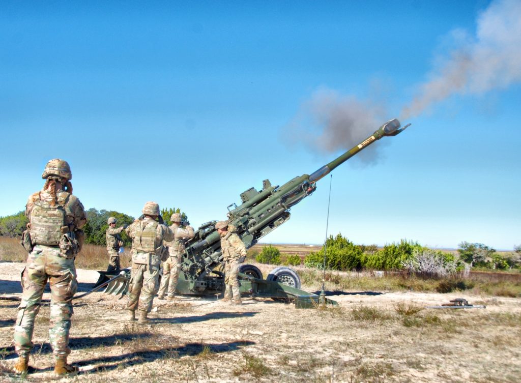
IMPROVED CAPABILITES: Howitzers like this one can fire high-explosive precision-guided munitions that use M-code GPS signals that improve jamming resistance, ability to determine enemy spoofing of GPS signals and enhanced cryptography. (Photo by Staff Sgt. Desmond Cassell, DVIDS)
CONCLUSION
This M-code live-fire developmental test has been subsequently documented in a recently issued final test report by JPEO AA. The results of the M-code live-fire developmental test verified that hot-start M-code GPS satellite data can be digitally disseminated across the fires network to the weapon system which, in turn, use this data to execute precision-guided munition fire missions.
This was the first-ever live-fire guide-to-hit demonstration using network-provided hot start M-code GPS satellite data to execute precision-guided munition fire missions. JPEO AA’s NA2 prototype system-of-systems capability enables warfighters to execute precision-guided munition fire missions in vertical-terrain-challenging and GPS-contested environments.
IDKFor more information, contact Becky Gilbert at JPEO AA Public Affairs at rebecca.s.leonard3.ctr@army.mil.
PAUL MANZ serves as chief technology officer for Joint Program Executive Office Armaments and Ammunition at Picatinny Arsenal. He is a Lean Six Sigma Black Belt, Institute of Electrical and Electronics Engineers Senior Member, and a recipient of the Ancient Order of Saint Barbara. He was recognized as the Top Engineer in DOD, the defacto Top Electrical/Electronics in Federal Government, and the Top Precision Weapons/Munitions Engineer in the U.S. He has authored and presented numerous invited papers and articles and holds a dozen U.S. patents.
THOMAS BLENK serves as the director of Assured Precision Weapons and Munitions under the Joint Program Executive Office Armaments and Ammunition at Picatinny Arsenal. He has over 10 years of navigation experience and made significant contributions to various precision-guided munition and weapon programs, and he is currently pursuing his doctorate in electrical engineering from Stevens Institute of Technology.