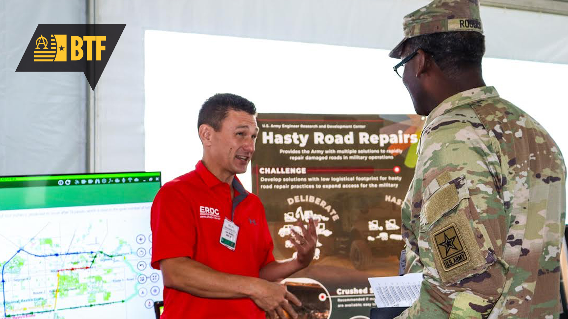
John Rushing, left, speaks with an S&T Day attendee about ENROUTE Mission Analysis for Convoy Planning and Route Repair, which fills a capability gap in engineering reconnaissance. (Photo by Brittany Stokes, USAASC)
SCIENCE AND TECHNOLOGY DEMONSTRATION HIGHLIGHTS ERDC’S ACCOMPLISHMENTS
by Jacqueline M. Hames
Muddy conditions and the threat of rain did not deter attendees at the Science and Technology (S&T) Day Demonstration. Parking near the exhibitor tents was full, and guests had to be shuttled down to the event site from the Compound 300 Visitor’s Center. Once they arrived, guests were ushered into a large tent or directed to oversized displays in the open air. Complimentary popcorn and water added to a festive feel throughout the event.
On that overcast day—Sept. 25, 2025—Army agencies gathered to demonstrate their latest scientific and technological achievements on Fort Belvoir, Virginia. Among the demonstrations were key technologies from U.S. Army Engineer Research and Development Center (ERDC), including ENROUTE Mission Analysis for Convoy Planning and Route Repair; Bi-Directional Inverter Deployable System (BIDS); and Pathfinder3D: Visual Terrain Reference and Navigation. The U.S. Army Combat Capabilities Development Command, U.S. Army Space and Missile Defense Command, Army G-1 Army Research Initiative and the U.S. Army Medical Research and Development Command also had dynamic displays at the demonstration.
One of the first demonstrations attendees saw inside the tent was for ENROUTE Mission Analysis for Convoy Planning and Route Repair. John Rushing, Ph.D., was on hand to answer questions and discuss the technology. Rushing, with a doctoral degree in civil engineering from Texas A&M University, is a research civil engineer at ERDC’s Geotechnical and Structures Laboratory. He is the project manager for the power projection in anti-access/area denial environments. The ENROUTE technology “fills a capability gap in engineering reconnaissance,” Rushing said.
It helps Soldiers understand the condition of the routes ahead and whether they can support a convoy. “We input information about the pavement structure. [ENROUTE] incorporates climatic effects to capture changing environmental conditions,” Rushing explained. It also considers the convoy make-up, including the type and weight of each vehicle. The analysis engine takes that data and lets Soldiers know how many passes over that area the convoy can make, which is then compared to the Soldiers’ objectives to output a go/no-go condition, he added.
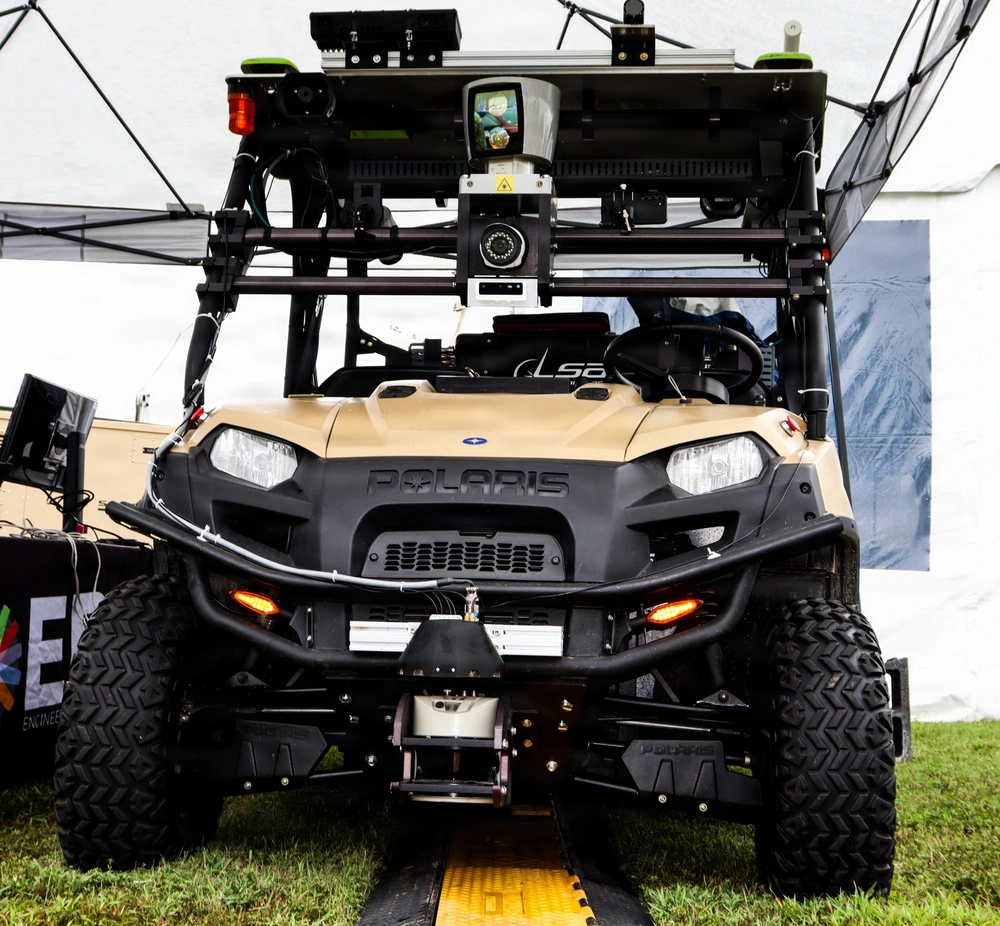
Pathfinder3D, a type of GPS that maps terrain in degraded or denied environment to provide accurate locations, mounted on a demonstration vehicle. (Photo by Brittany Stokes, USAASC)
The technology—which is meant for rural or damaged areas—ensures survivability for the warfighter. “It allows them to perform that analysis before the mission and get better confidence that the route is going to be suitable,” Rushing said.
Another technology designed to assist Soldiers with navigating is Pathfinder3D, a type of GPS that maps terrain in degraded or denied environments to provide accurate locations without LIDAR (Light Detection and Ranging) or radar from ERDC’s Geospatial Research Laboratory. Instead, onboard cameras are used to reference a Soldier’s position. “We’re trying to use the existing sensors that Soldiers have access to on the dismounted side,” William Shuart, geographer and remote sensing scientist, said. Shuart is also the program manager for Pathfinder3D.
“The current environment has taught us that GPS is the first thing that gets canned on the battle space, and so alternative position, navigation and timing strategies are always needed,” Shuart said.
Pathfinder3D takes foundational geospatial data gathered from sensors, like Buckeye or One World Terrain, and distills it down to keep pertinent information Soldiers can use at the tactical edge. “We’re essentially taking a picture with the Samsung S23 device, we’re then generating a synthetic horizon. We’re extracting that, and we’re matching it to a horizon that’s sitting on our phone. And then we’re seeing how accurate we are from our original synthetic horizon and the horizon that we generate from the image itself,” Shuart said.
Of course, none of these systems can operate without power—something the scientists at ERDC can also provide with BIDS. Jonathan Goebel, the operational energy program manager for ERDC, explained that the system can pull power in and push power out simultaneously.
“We’re able to input power from generators, from solar, from host nation power at different voltages, and we’re able to output power the same way,” he said. “At the same time that we’re bringing power in to charge batteries, we can also output power and power the load at the same time.”
The two-way conversion allows BIDS to take control of any generators in the field, power the load while also charging the energy storage—which saves fuel and reduces engine run time by about 80%, Goebel explained.
“Using BIDS allows us to run the generator less, and when the generator is running, it operates at max capacity, which eliminates wet stacking issues and reduces maintenance,” he said.
ERDC had several other technologies featured at the event. Check out the major highlights at www.erdc.usace.army.mil, https://www.facebook.com/ArmyERDC/ and https://x.com/ArmyERDC/.