PEO STRI takes a unique approach to tracking modeling and simulation requirements, using Google Earth to communicate visually what a synthetic terrain representation needs to show—clear, detailed requirements generated in a fraction of the time it takes to describe the same needs in a text document.
By Mr. Thomas Kehr and Mr. Trey Godwin
Each of these entries describes relatively the same location in geographic coordinate space, but without a visual reference or map they can be difficult to decipher. Maps are indispensable tools that help humans understand, in a visual way, important facts about the surface of the Earth. Geographic coordinates and maps go hand in hand in establishing where we are and where we want to go.
Advancements in computing have empowered the Army, through modeling and simulation software, to transform maps into synthetic terrain representations that are used in simulation systems and devices to enable virtual and constructive training. The development, testing and evaluation of synthetic terrain representations for modeling and simulation applications rely heavily on visual inspection by all stakeholders. The representation of terrain for a given geographic area must be visually verified and validated to ensure that the synthetic terrain reflects the appropriate “look and feel” of the terrain and environment, while also meeting the requirements of a given capability manager. Unlike other weapon systems and training devices in which requirements can readily be interpreted through a text-based requirements document or system specification, synthetic-terrain representation requirements present a unique set of challenges for proper interpretation.
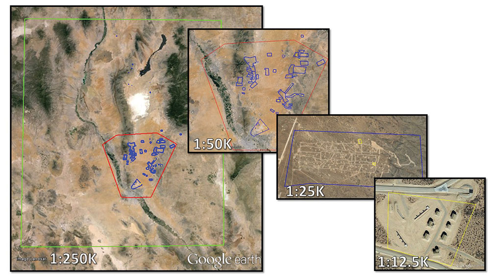
FIGURE 1 GETTING CLOSER
Graphical KML representation of four fidelity scales for the Fort Bliss, Texas, terrain representation requirements, from least detailed to most detailed moving from left to right. Training areas are shown in more detail, ancillary areas of Fort Bliss in less. When the product in question is a map, it’s much easier to communicate the requirements visually using map software rather than describing them in a text document. (SOURCE: Google Earth Pro)
Recent improvements and widespread availability of consumer geographic and mapping software applications, such as Apple Maps and Google Maps, have revolutionized the once niche field of commercial mapping. The Synthetic Environment Core (SE Core) program, under the Program Executive Office for Simulation, Training and Instrumentation (PEO STRI), has implemented a solution to the above-mentioned requirements through one of these commercially available consumer mapping applications—Google Earth Pro. Google Earth Pro builds on the capabilities of Google Earth and the less robust Google Maps by adding advanced geographic analysis features such as improved geographical measurement calculations and the ability to import data from other geographic software applications.
REQUIREMENTS CHALLENGES
Traditionally, synthetic terrain representation requirements were compiled through a text-based database content requirements (DCR) document, which contained details such as geographic boundaries, terrain fidelity within a given extent, and geospecific 2-D and 3-D model features (such as those in Table 2). The SE Core team identified several challenges when using this text-based DCR, especially when sharing the document with multiple organizations and stakeholders. A text-based requirement describing a geographic location in a specific coordinate space can be sufficiently detailed, but without a corresponding visual representation, the description requires further geospatial analysis to fully comprehend.
Inversely, a requirement such as one stating that the contractor “shall develop a synthetic terrain representation of Fort Bliss” is overly vague and requires extensive investigation to develop associated derived requirements. For example, which training ranges are required? Is there a requirement to develop areas outside of training areas? What is the required fidelity of the maneuver areas? By implementing a standard-terrain-fidelity-scale specification and a commercial geospatial-visualization tool, these challenges can be eliminated, while also promoting a collaborative process of requirements development.
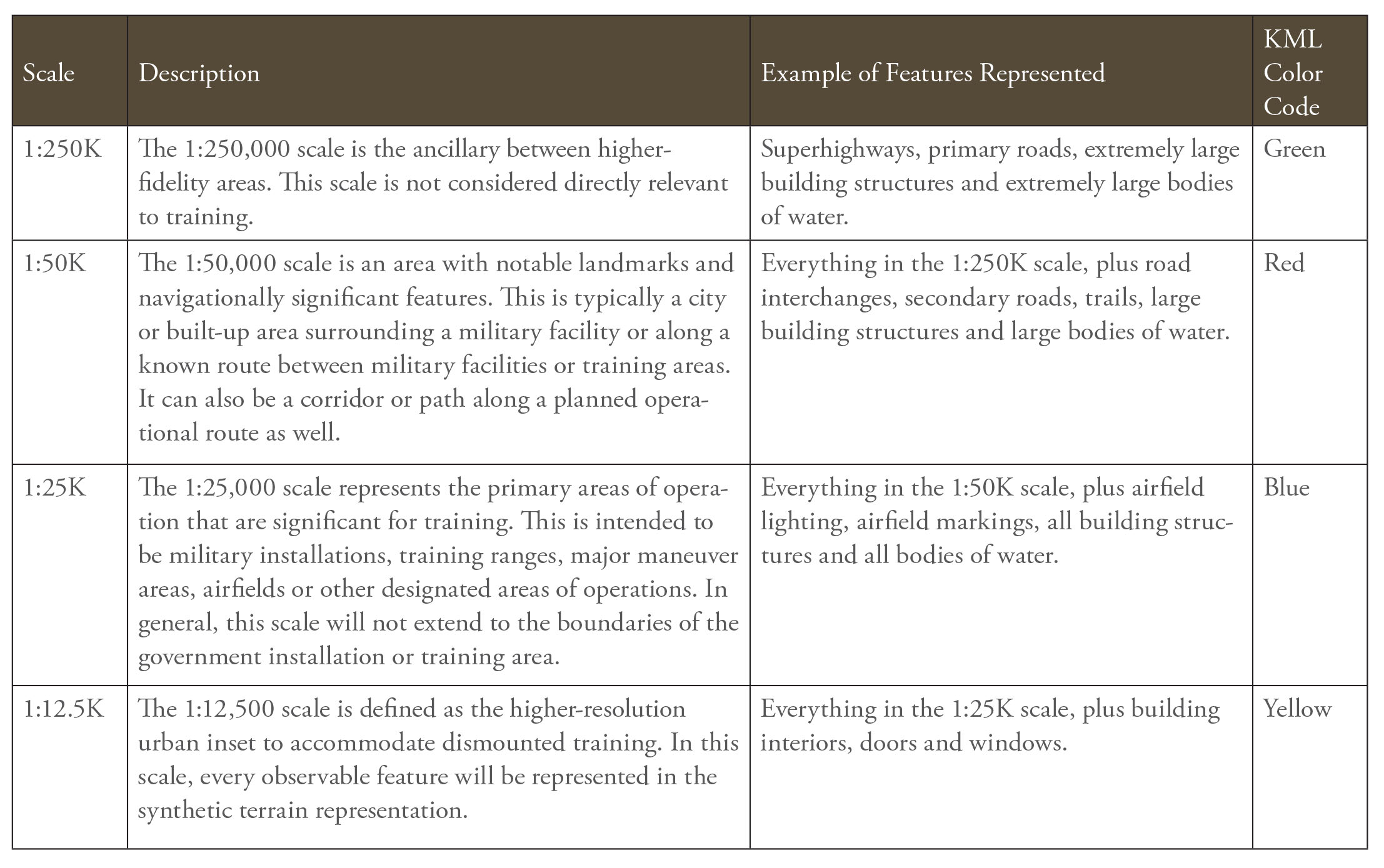
TABLE 1 FEATURES TO SCALE SE
SE Core Terrain Representation Scale Specification Standard. (SOURCE: SE Core Scale Specification version 2.0)
TERRAIN SCALE SPECIFICATION
SE Core has implemented a terrain scale specification document that standardizes how geospatial terrain features will be collected and represented within a given synthetic terrain representation product. This scale specification closely follows the National Geospatial-Intelligence Agency standard map scales of the joint operations graphics (JOG) and topographic line map (TLM) series to promote a common vernacular when sharing requirements between stakeholders.
The accompanying scale-specification table provides a high-level description of each SE Core terrain scale and examples of represented features in each. See Table 1, and Figure 2.
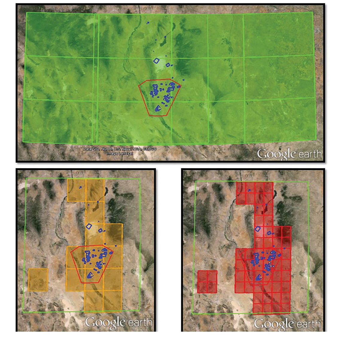
FIGURE 2 STANDARDS TO SCALE
SE Core created a scale specification table to standardize how features are captured on terrain representations. SE Core’s common specifications rely on industry-standard graphics, so that those producing the requirements and those meeting them speak the same language. At top, a KML representation of joint operations graphics, with examples of topographic line map series (TLM-100, bottom left; TLM-50, bottom right), capture requirements for Fort Bliss terrain. (SOURCE: Google Earth Pro)
GRAPHICAL DATABASE CONTENT
Using the terrain scale specification Google Earth Pro can be used to visually document the terrain requirements through the Open Geospatial Consortium Keyhole Markup Language (KML) standard. KML is an international standard that allows the creation of geolocated pinpoints and overlays. KML files can be created and shared easily through Google Earth Pro with a very shallow learning curve.
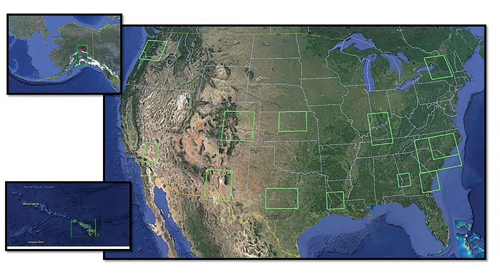
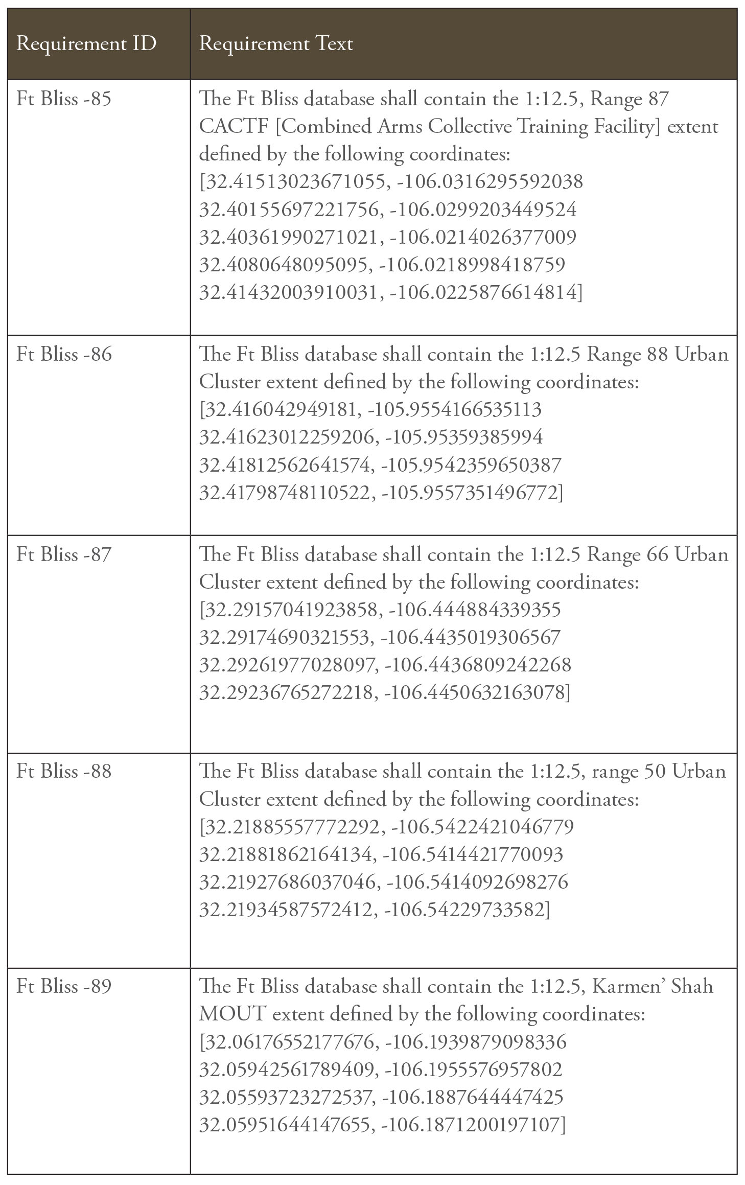
The SE Core team, a synthetic terrain stakeholder, or the capability manager can generate a graphical DCR by referencing the KML color code associated with each scale specification standard. Figure 1 provides an example of this using the SE Core Fort Bliss terrain requirements. A box of approximately 300 km squared represents the 1:250K ancillary area of the terrain representation. The figure illustrates the 1:50K area comprising the primary Fort Bliss training reservation. A primary live-fire range, the Digital, Multi-purpose Range Complex (DMPRC), is captured as a 1:25K area, and the associated DMPRC air-to-ground integration villages are captured through the 1:12.5K fidelity area. Google Earth Pro’s measurement functions also allow for accurate area and perimeter calculations for each overlay to aid in the collection of metrics and generating reports.
The Google Earth Pro KML file approach to a DCR also allows for the capture of other required terrain representation components that would otherwise be burdensome to represent in a textual format, such as aerial imagery requirements, elevation data requirements, associated raster map products and geospecific model locations. Additionally, the KML standard allows for the inclusion of embedded metadata in the overlay file, which can be used to add comment fields to the KML overlays that can easily be displayed through the Google Earth Pro interface. (See Figures 3 and 4.) These comments can add useful reference data on a particular training area or provide additional requirements commentary—for example, the required terrain export formats and files for a given geographic area. This data can be useful for the synthetic terrain developers as well as the test and evaluation personnel.
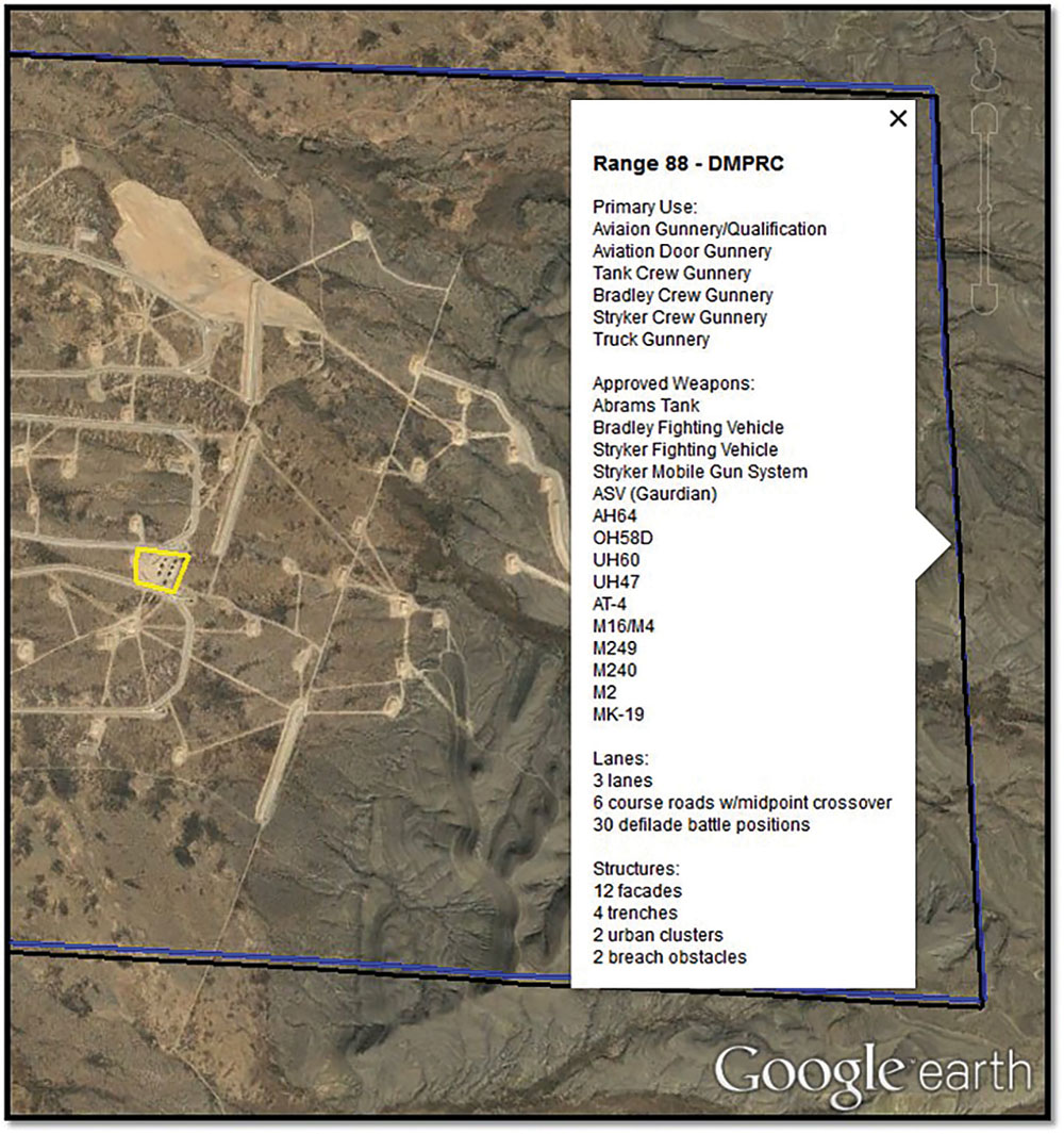
FIGURE 3 VISUAL AND VERBAL
Maps and text aren’t mutually exclusive ways to capture requirements. Creators of terrain requirements can add comments to Google Earth Pro, embedded in an overlay file. Here, a metadata comment gives additional reference data on the DMPRC live-fire range at Fort Bliss. (SOURCE: Google Earth Pro)
COLLABORATIVE REQUIREMENTS DEVELOPMENT
The wide availability and public familiarity with Google Earth and Google Maps, coupled with the open KML standard, enable collaborative requirements development among stakeholders. Upon receiving an initial requirement to generate a terrain representation for a given geographic area, they can use Google Earth Pro, in conjunction with other geospatial references, to visually inspect the area to identify additional areas of interest (AOI) and secondary terrain features for the initial DCR KML document.
This initial document can then easily be shared with the capability managers, end users and additional terrain stakeholders to provide feedback necessary to form the baseline requirements document. Because end users can review a visual representation of the requirements, they can easily identify missing AOIs or terrain features early, which results in less rework in the verification and validation phases of the terrain representation life cycle.
The underlying XML schema of KML allows this graphical DCR to be converted to a text format, with Microsoft Excel scripting, for use in generating test procedures or as a programmatic requirement.
Google Earth Pro also allows for the simultaneous display and storage of multiple KML DCR documents. (See Figure 5.) This feature can be useful as an interactive terrain catalog that allows users to visualize global coverage of where an organization has developed terrain.
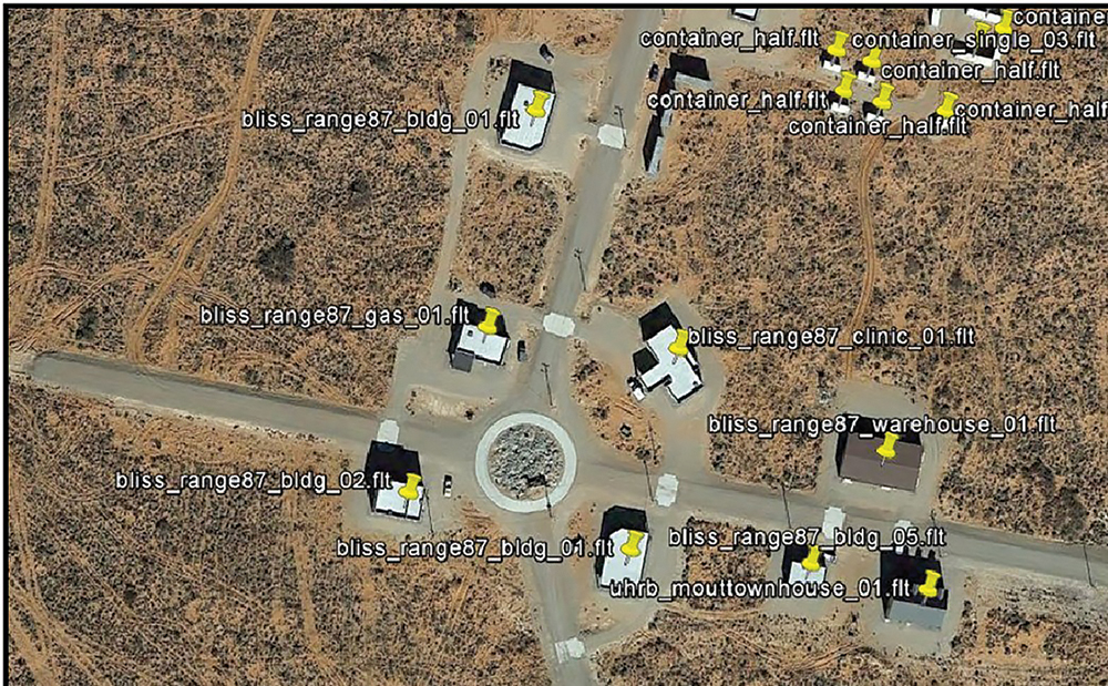
FIGURE 4 REQUIREMENTS IN HIGH RESOLUTION
Using map software to capture requirements for terrain representation enables the requirements generator to capture information that would otherwise be burdensome to define. For example, it would take a lot of text to describe the geospecific locations easily shown here in high resolution in the KML file. (SOURCE: Google Earth Pro)
CHALLENGES AND FUTURE WORK
In our experience, Google Earth Pro can readily be obtained on federal computer systems given appropriate system administrator approval. Google Earth Pro is a cybersecurity-approved software item for which Google used to charge an annual license fee, but it is now freely available. The process of requirements tracking and development using KML files requires bidirectional collaboration through Google Earth or Google Earth Pro; therefore, if a stakeholder does not have access to Google Earth, the process can be stalled.
There is a workaround when one user does not have access to Google Earth. Someone with the software can create a slide presentation or PDF containing screenshots of each scale and AOI included in the KML file. This can be time-consuming, but is still more efficient and user-friendly than a traditional text-based requirements document. The SE Core program is looking at methods to better automate the screen capture of KML overlays on Google Earth.
Unlike traditional word processing software, Google Earth Pro and KML files currently do not include any functions for tracking changes or edits. To view differences between two identical KML files, they must be laid onto each other and toggled on and off to visualize the changes. Other methods can also be used, such as temporarily swapping the color of an AOI overlay when sending it to the requirements management authority. Until Google provides a better mechanism for tracking changes, it is imperative that users apply a rigorous configuration management process to maintain KML-based requirements documents.

FIGURE 5 CATALOGING COVERAGE
Google Earth users can store multiple KML documents, which has allowed SE Core to create a portfolio—easily accessible and ready for collaboration—of its current terrain coverage. (SOURCE: Google Earth Pro)
CONCLUSION
The SE Core program and its confederate simulation-system programs, such as the Aviation Combined Arms Tactical Trainer (AVCATT), the Close Combat Tactical Trainer and the Games for Training program, have met with great success using Google Earth Pro and KML files to visually track live, virtual, constructive and gaming terrain representation requirements. In conjunction with the U.S. Army Training and Doctrine Command’s Program Office for Terrain at the National Simulation Center in Fort Leavenworth, KS, terrain representation requirements can be generated in a fraction of the time previously spent on a text-based solution. Moreover, the requirements are in a portable and graphical format for efficient feedback and collaboration by terrain and simulation stakeholders.
Unambiguous terrain requirements are a key feature of the graphical DCR process, and the union of visual indicators with a graphical geographic interface guarantees that all stakeholders have a common frame of reference, which reduces the time spent communicating and solidifying a given synthetic terrain requirement. This explicit requirements capability, coupled with rapid requirements generation and collaboration, results in higher-quality deliverables to better meet customer and end-user needs and expectations.
For more information, go to the SE Core program website at www.peostri.army.mil/PMConSim/SECore.jsp; or contact the SE Core’s Assistant Project Manager Frank Rhinesmith, at frank.d.rhinesmith.civ@mail.mil or SE Core Chief Engineer William Reese, at william.c.reese16.civ@mail.mil.
MR. THOMAS KEHR is the government integration and test lead systems engineer for the SE Core program at PEO STRI and is responsible for overseeing the day-to-day testing and evaluation of SE Core terrain databases, as well as managing the overarching database test schedule in the live, virtual, constructive and gaming system environments. He holds bachelor’s and master’s degrees in electrical engineering and is pursuing his doctorate in modeling and simulation from the University of Central Florida. He is Level III certified in systems engineering, Level I certified in science and technology management and Level I certified in program management. He is a member of the Army Acquisition Corps.
MR. TREY GODWIN is a visual systems engineer for the SE Core program at PEO STRI. He is responsible for the execution of SE Core terrain database productions and is the advocate for aviation training programs, with an emphasis on the Longbow Crew Trainer and AVCATT. He holds a B.S. in geography and environmental science from Stetson University. Before joining the SE Core program, Mr. Godwin accumulated nearly 10 years of experience with industry partners developing terrain databases for virtual simulation systems.
This article was originally published in the October – December 2015 issue of Army AL&T magazine.
Subscribe to Army AL&T News, the premier online news source for the Acquisition, Logistics, and Technology (AL&T) Workforce.  Subscribe